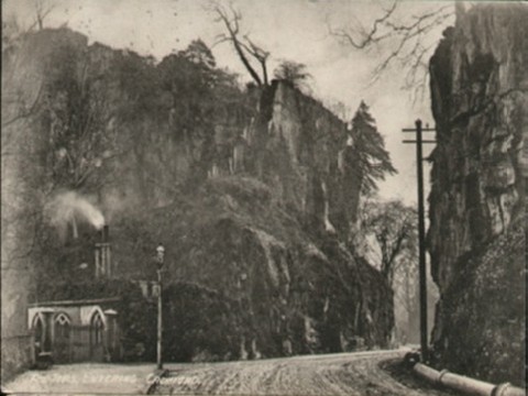
The Tors Entering Cromford, Cromford
The caption on this postcard says “The Tors Entering Cromford” but it is actually within the boundaries of the Ecclesiastical District of Matlock Bath, looking towards Cromford, along what is now the route of the A6 Trunk Road. The ‘Via Gellia’ route from Bonsall (now the A5012) joins the roadway just around the corner on the right. The building you can see on the left was ‘Scarthin Lodge’, one of the gatehouse-lodges belonging to Willersley Castle, occupied as two separate dwellings - and, with the smoke coming out of its chimneys, looking somewhat surreal... At first glance, I'd thought it was a church! The present A6 roadway following the banks of the River Derwent between Matlock and Belper is a relatively newcomer, since sheer rock faces blocked some of the portions of its passage originally. The first riverbank route joining Cromford and Matlock was forged during the 18th century by two Nottingham men, Smith and Pennell, who had opened a hotel in Matlock Bath; and they created routes from Matlock Bridge in the north, and Cromford Bridge in the south to serve it. However Scarthin Rock itself was still an obstacle, and their route circumvented it. This postcard shows the first cutting through it, along a natural fissure, or ‘Nick’, blasted around 1815. Successive road widenings thereafter necessitated Scarthin Lodge being demolished, and further portions of the rock face being removed.[1] ‘Scarthin Nick’ is still marked on maps, but ‘The Tors’ are not! The postcard was published by J. Newton, The Post Office, Cromford, in about 1907; however the postmark shown on this copy is August 1912. This viewpoint is from the north (Matlock Bath) end.[2] (Information provided by Rosemary Lockie) References
Image contributed by Sheila Rimmington on 21st July 2001.
|
||
