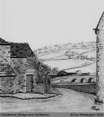
Grindleford - Sketch of Bridge and Old Bell Inn
Grindleford of yesteryear - compare this with a View to the Bridge today. Don's sketch is based upon an old photo dated circa 1888, which was taken looking down the Main Road (B6521) towards the Bridge, at the point where it meets the B6001 to Hathersage. The gable-end on the right, projecting into the roadway belongs to the Old Bell Inn, and it may also be seen in the far-left distance on an Old Postcard of ‘Red Lion Row’, looking at it in the opposite direction upwards from the Bridge. The view is much changed today. Shops have been built in the open ground on the right, and ‘The Bell Inn, Beerhouse and Hostelry’ partly demolished for road widening. It was kept in the mid-1800s by one Thomas GREEN, and understood to be one of the oldest properties in the village. During recent internal modernisation, amongst the plaster and horsehair, a tiny china figure was found built into a wall thought to be placed to keep out witchcraft.[1] The level of the highway has been raised so the remaining building is partly below road level, and the view of the Bridge from this point is now obscured by the shops. The land on the other side of the Bridge to the right has also been developed extensively. The tree in the middle distance is however still a prominent feature! The house which can be seen just over the Bridge is probably the Toll Bar Cottage, and in the middle distance, perhaps Nether Padley Farm - the original photograph is hazy, and we have taken some artistic licence. It must have been there at this time as it dates back to the 17th century (or earlier), and also used to be an Inn. Interestingly, the hillside slope on its left, still pastureland today, shows up on Google Satellite View (or similar) as having what appears to be an ancient "ridge and furrow" system. The land is now used mainly for grazing cows and sheep, and few arable crops are grown, but at a time when the village needed to be self-sufficient, wheat, roots and barley may have been produced. It is likely to have been the best place for crops on the Nether Padley side of the Bridge, with its gentle slope down to the flood plain by the river, since everywhere else is steeper! (Information provided by Rosemary Lockie) Reference
Sketch contributed by Don Rimmington on 15th July 2004.
|
||
