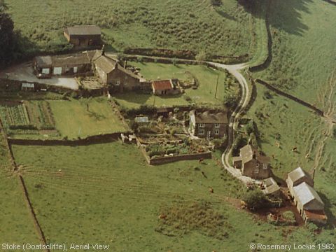
Aerial View, Stoke
This little cluster of one house, and two farm-steads is sited on an eastward-facing slope of the Derwent Valley, just outside Grindleford. The original aerial photograph has been ‘enhanced’ to remove 20th century additions to the houses, to show each of them more nearly approximating their basic plan of ‘two-up, two-down’. The houses themselves are believed to date from the 17th century. The one in the middle, where I was born, had the appearance of being built in two separate stages, with the older part (‘one-up, one-down’) on the right, with signs of another doorway at the right hand end which had been blocked up, and a definite “join” in the stonework in the middle of the property above the present doorway. Alternatively, if the middle divide is not significant, it might have been simply the doorway where the animals went in and the plan would have been of the traditional ‘long house’, where equal floorspace was devoted to animal welfare. However within living memory there is no record of it ever being a farmstead, whereas the other two houses were working farmsteads, with the buildings nearest to them used for cattle, and storing hay. The one at the top of the photograph (west of the site) has a cellar, and so rumour had it, the ghost of a former resident, a nurse. Neither is there any record of it providing accommodation for more than one household. The Stoke 1901 Census return would have included these properties, but it has been impossible for me to determine which houses were which, so whilst there appear to be more households recorded at Goatscliffe than at present, it has not been possible to establish whether that was because the present buildings may have had separate entrances for more than one household, or whether separate buildings existed, which have since been abandoned. There is some evidence of the latter being the case elsewhere in the area, as my mother referred to an old man named Robert Higginbotham living in a property which is now derelict, “underneath the road” - that is, on the slope down from the Stoke Road (B6001) to the River Derwent. If this was the Robert Higginbotham in the parish records, he died in 1851 (buried 26 Dec 1851 at Eyam), which was 50-plus years before she was born! But even so, this does not mean the tradition was inaccurate... people in country districts do have long memories! The image is taken from a purchased aerial photograph in June 1962. (Information provided by Rosemary Lockie)
Image contributed by Rosemary Lockie on 26th October 2002.
|
||
