|
The Boundaries...
Today, “Stoke” as a separate entity does not
officially exist, as in 1911 it became part of Grindleford.
Its boundaries were delimited by Goatscliffe Brook
in the north, the River Derwent in the east, and Stoney Middleton Brook
[2]
in the south. Its western boundary is less easily defined,
being delineated by moorland and fields bounding Magclough Farm
land. Today, obviously, we have a different concept of our
bounds to those which governed our ancestors' lives. Likewise
their regular routes and trackways would in some cases have
differed significantly from those we are familiar with now. It
has been said that the Turnpike era marked the beginnings of
the network of roads that serves us in the present day, but I
can imagine their advent might have been greeted with the same
mixed feelings as did the construction, and opening of the M1,
in 1959! At a local level, whilst Stoke's residents might have
welcomed the improvements in transport which ensued, the peace
of this rural settlement may well have been as rudely disturbed
as it might be today, for towns and villages when a new Motorway
passes nearby! More noisy carriages passing through, and
suddenly having to pay for the privilege of going to
Bakewell market!
And of course there were no Neighbourhood Action Groups...
The First Turnpikes...
The first Act of Parliament to enable the collection of money
for repair of roads was passed as long ago as 1663, for part of
the Great North Road (A1) between Wadesmill in Hertfordshire
and Stilton in Huntingdonshire,
[3]
but it wasn't until the next century that the so-called
‘Turnpike Era’ took off. Acts of Parliament enabled
the creation individual Turnpike Trusts, under which those invested
as its Trustees - possibly a mix of philanthropists, local
dignitaries and businessmen - were empowered to set up
tollgates and collect tolls from those using that particular stretch
of turnpike to facilitate its upkeep. The last of these Acts was
passed in 1836, by which time 942 Acts for new Trusts had been
passed. Numerous other Acts were also involved, some to close
legal loop-holes, others to facilitate commerce, and yet others
to sanction the repair of existing turnpikes. The amount of toll
levied varied, but there were very few exceptions. One such
example was an Act of Parliament of 1785, whereby mail-coaches
were exempted.
Also I suspect that unlike the tollgate on the ‘Rock Island Line’,
[4]
where a load of pigs could go through free of charge, and a
load of pig-iron could not, livestock would not have travelled free!
On the other hand, there were reported instances of travellers
avoiding a tollgate by taking a circuitous route, with greater
or lesser success...
The Chesterfield to Hernstone Lane Head Turnpike...
The first roads to be turnpiked were the major ones - the Great
North Road (today's A1), the road from London to Chester (the A5),
and the road from London to Carlisle, today's A6. Several Acts
involving the A6 were passed in 1737, and an Act for the
Chesterfield to Worksop (A619) the following year. But roads
through the Peak District weren't long in following. The first
Act for the Turnpike known by the description of Chesterfield
& Hernstone Lane Head, of which the Turnpike passing
through Stoke was part, was passed in 1758.
[5]
The description - “Chesterfield to Hernstone Lane Head”
(near Peak Forest - on today's A623) may appear to be confusing
at first for a road through Stoke, but it appears that was the
designated name of the Turnpike, including its branches.
Thus one of the first announcements we see in the Derby Mercury
to mention Stoke refers to it in that capacity.
[6]
Notice is hereby given,
THAT a MEETING will be held on Saturday
the Ninth Day of December next, at the House of Mr.
JOSHUA FIDLER, known by the Sign of the Falcon in Chesterfield,
by Ten of the Clock in the Forenoon of the same Day, to
consider further of an Application to Parliament at the next
ensuing Session, for a Turnpike-Road from Chesterfield to the
Turnpike-Road at Hernstone-Lane-Head, leading to Chappel-en-le-Frith;
and for a Branch out of the same, from about the
Middle of the East-Moor, near Clod-Hall, thro' Baslow, Hassop,
and Bakewell, to the Turnpike-Road near Newhaven House,
which leads from Ashbourne to Buxton, and for another Branch
from Hassop, thro' Calver, and by Stoke to the Turnpike-Road
at Grindleford Bridge, which leads from Sheffield to Buxton:
And likewise to consider of raising Money for those Purposes.
One of the problems early coach travellers on this, and
other turnpike routes were the gradients, since initially at least
turnpike routes followed the old packhorse ways, which went
‘up hill and down dale’, to avoid river
valleys which were prone to flooding. So, for instance the
Turnpike from Sheffield to Buxton, which passed through the
other (north) end of Grindleford village to Stoke, after
crossing Grindleford Bridge from the Sheffield direction,
would have turned right up Sir William Hill, past the School,
and over the top of Sir William to Great Hucklow. Apparently
it was not uncommon for passengers to be asked to get out
and walk in such circumstances, so the horses could pull
the coach to the top of the hill safely. Poor horses...
What to do about Knouchley Hill...
Meanwhile back at the Stoke end of Grindleford, approaching
the Toll Bar from Calver, coaches were faced with a formidable
climb up Knouchley Hill, which is mentioned by Farey as
having a gradient of 1 in 6 and as not having been improved
when he was writing in 1817.
[7]
This is interesting, as in Farey's time the road up
Knouchley Hill evidently took a “line of sight” route.
He was a very accomplished Mineral Surveyor, and it would
seem that he took to heart the subtext of his publication
General View of the Agriculture of Derbyshire, with
observations on the means of its improvement, drawn up
for the consideration of the Board of Agriculture. He
drew attention to the fact that too frequently turnpikes had
been laid out to follow existing trackways, and were
crossing valleys at right angles, a description which
could aptly describe the original route, whereas the more
oblique and easy descents which might in most instances be had
could equally describe the “S” bend of today's B6001!
[8]
Unfortunately, more than 50 years were to elapse before the
changes he suggested were implemented at Knouchley. The
Map illustration on the right of this page shows an outline
(in red) superimposed on a modern Map, of the route as it
may have been in Farey's day. This is based on a Surveyor's
Plan of 1866, of the proposed new route.
[9]
However, present day evidence suggests the old roadway which
was to be replaced may not have been so clearly delineated.
There may have been several regularly-trod trackways, depending
on the state of the terrain, whether it was winter or summer,
and whether travelling by coach, cart, or on horseback.
[10]
Two possible routes from the present road north, in the
direction of Knouchley Farm are suggested by Google Satellite
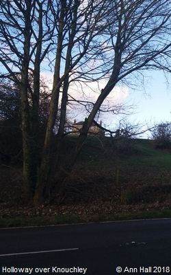
View (shown opposite). Ann tells me there is a hollow in the bank
where the more westerly of these two routes leaves the present day
road side (also illustrated, opposite), and enters the field.
Less easily seen are opposing routes south, to meet the A625 so
these might need a little more imagination!
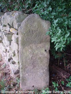
The route I've shown also takes into account the position of a
surviving example of one of the obligatory guideposts, which an
Act of 1702 required every parish to erect where highways met,
providing directions to nearby market towns. In this case the
stone has the lettering “To Sheffield” on its most
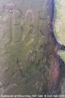
visible side. Less easily seen, on its north west side, are the
letters ‘Bake’ - evidently indicating the direction
of Bakewell. Below is an initial letter 'A', followed by two more
letters, less easy to decipher. Perhaps it says “Ashbourne”,
with the ‘S’ reversed, and indeed the road would
reach Ashbourne eventually (the Turnpike-Road near Newhaven
House which leads from Ashbourne to Buxton, above), but
conversely that might be ‘Wishful Thinking’ on my part!
The position of the guidepost is marked with a ‘star’
on the Map, and can be seen on the right of the present day public
footpath from (the west of) the main road past Knouchley Farm.
[11]
Farming out Collection of Tolls...
The next stage, after the turnpikes were laid, the barriers
were installed, and properties available, was to arrange
for toll collectors to collect the tolls. The following
notice from the Derby Mercury gives a flavour
of the processes involved:
Turnpike from Chesterfield to Hernstone-Lane-Head.
Notice is hereby given,
That the acting Trustees of this Road, at their last Meeting,
resolved to let the Tolls at the Gates of Ashgate, Calver, Stoke,
Wardlow-Mires, Baslow, and Conksbury.
All Persons who are willing to farm the said several
Gates, are desired to deliver their Proposals in Writing,
for the farming each Gate separately, to the acting
Trustees, at their next Meeting, at the Angel in Chesterfield,
on Thursday, the 7th Day of November next.
By Order of the Trustees,
John MANDER, Clerk.
[12]
Thereafter advertisements were appearing regularly
in the Mercury for Auctions to let the collection
of Tolls “for the Term of One Year or more” to
the highest bidder, but with the proviso that for the Tolls
to be let, there must be at least two Bidders. The
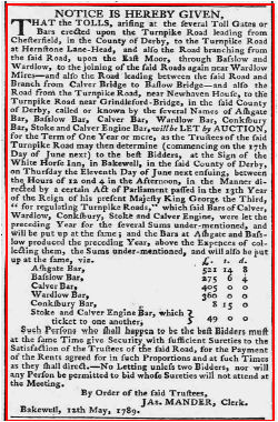
advertisement below is a typical example:
NOTICE IS HEREBY GIVEN,
That the TOLLS, arising at the several Toll Gates or
Bars erected upon the Turnpike Road leading from
Chesterfield, in the County of Derby, to the Turnpike Road
at Hernstone Lane-Head, and also the Road branching from
the said Road, upon the East Moor, through Baslow and
Wardlow, to the joining of the said Roads again near Wardlow
Mires - and also the Road leading between the said Road and
Branch from Calver Bridge to Baslow Bridge - and also the
Road from the Turnpike Road, near Newhaven House, to the
Turnpike Road near Grindleford-Bridge, in the said County
of Derby, called or known by the several Names of Ashgate
Bar, Basslow Bar, Calver Bar, Wardlow Bar, Conksbury
Bar, Stoke and Calver Engine Bar, will be LET by AUCTION,
for the Term of One Year or more, as the Trustees of the said
Turnpike Road may then determine (commencing on the 17th
Day of June next) to the best Bidders, at the Sign of the
White Horse Inn,
[13]
in Bakewell, in the said County of Derby,
on Thursday the Eleventh Day of June next ensuing, between
the Hours of 12 and 4 in the Afternoon, in the Manner
directed by a certain Act of Parliament passed in the 13th Year
of the Reign of his present Majesty King George the Third,
“for regulating Turnpike Roads” which said Bars of Calver,
Wardlow, Conksbury, Stoke and Calver Engine, were let the
preceding Year for the several Sums under-mentioned, and
will be put up at the same; and the Bars at Ashgate and Basslow
produced the preceding Year, above the Expences of collecting
them, the Sums under-mentioned, and will also be put
up at the same, viz.
| | £. | s. | d. |
| Ashgate Bar | 521 | 14 | 8 |
| Basslow Bar | 275 | 6 | 4 |
| Calver Bar | 405 | 0 | 0 |
| Wardlow Bar | 360 | 0 | 0 |
| Conksbury Bar | 8 | 15 | 0 |
| Stoke and Calver Engine Bar, which ticket to one another | 49 | 0 | 0 |
Such Persons who shall happen to be the best Bidders must
at the same Time give Security, with sufficient Sureties to the
Satisfaction of the Trustees of the said Road, for the Payment
of the Rents agreed for in such Proportions and at such Times
as they shall direct. - No Letting unless two Bidders, nor will
any Person be permitted to bid whose Sureties will not attend at
the Meeting.
By Order of the said Trustees
JAs. MANDER, Clerk,
Bakewell, 12th May, 1789.
[14]
There remains one question to address, raised by the above notice.
What is the significance of “Calver Engine Bar”?
This was, I assume, what became known as a “weighing engine”.
An Act of Parliament of 1741 ‘gave trustees of roads authority
to have built, at any or every toll-gate, weighing engines for weighing
all carriages and goods passing through the toll-gate, and to take, in
addition to the regular toll, a further duty of twenty shillings per
hundredweight for all above sixty hundredweight, which extra payment was
also to be applied for mending the roads”.
[15]
Evidently this had been intended originally to discourage the carriage
of heavy loads, as much as to provide extra revenue; but as one might
imagine, weighing engines were not popular; indeed,
“immediately
after the law was passed, men with heavy loads... would unload part of
their goods before driving on to the weighing engine, and then reload after
they had passed. In other cases... men would sometimes go out of their way,
through narrow lanes and side roads, till they had passed such a place...
In reality, comparatively few of these engines had been erected, for it was
merely optional with the road trustees whether they established them or
not”. [15]
In such circumstances one might imagine the “Calver Engine”
was a mixed blessing! And one can't help wondering whether was Calver,
or Stoke, ever a scene of “Turnpike Riots ”? Perhaps
I'll leave that question for another day!
Meanwhile, here is another link to Ann's account of
Stoke Toll House (link to a PDF file, 5,321K)
|
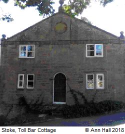
Toll Bar Cottage, Stoke
© Ann Hall 2018.
|

