Stoney Middleton, Plan of 1840The original turnpike through Stoney Middleton followed a devious route in comparison with the road today, though of necessity, to avoid a huge outcrop of rock in the Dale. This was blasted away for the present route (shown in blue on this sketch) to be made. Here is a copy of the Plan for that ‘new’ road as drawn up in 1840. 
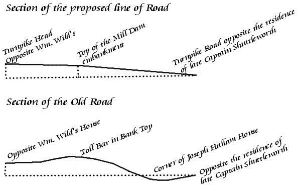
Editor's NotesNo street names were shown on the original plan - only the names of the pubs! Text in RED is my addition to indicate present-day names of streets, and the approximate location of the Church. The original of this plan was drawn to a scale of 4 chains to one inch, and was accompanied by drawings (below) of cross sections of the road over the Bank as it was, and of the proposed route. The cross section of the old route reveals it dipping down towards Church, with its lowest point described as ‘Corner of Joseph Hallam House’; then rising to its highest elevation by the old Toll Bar (marked above as ‘The First Toll House’). It then drops down again to ‘opposite Wm Wild's House’ - above marked as the ‘Boot and Shoe’. The cross section of the new route shows a gentle gradient, rising as a smooth curve, so it is shown not only as much straighter laterally, but more attractive in a vertical direction too! Clearly the new road was an offer the villagers couldn't refuse! 
The ‘Boot and Shoe’ later became ‘The Grouse’, with the ‘Denman Arms’ becoming ‘The Sun’. The ‘Stags Head’ as shown here was demolished to make way for the new road, and the licence transferred to new premises up the High Street; The Moon Inn's licence was transferred in 1842 to the premises adjacent to The Dower House (Shuttleworth's), where it remains today. The Mill Dam has been filled in, and is now a pleasant grassed and garden area. This ‘Brave New Road’ is now part of the main A623 road between Chesterfield and Manchester. Information provided by Rosemary Lockie. |
|