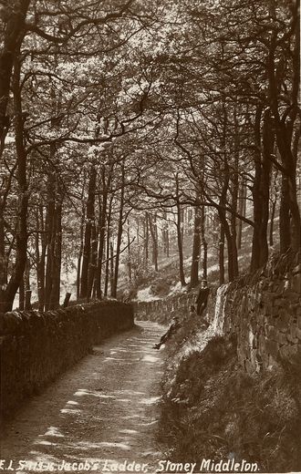
Pictures of the Past : Jacob's Ladder, Stoney Middleton
Jacob's Ladder was possibly a major thoroughfare in the past, and in fact is marked as a roadway of similar width to the High Street on Sheet 111 of the OS (1:63,360) New Popular Edition map (1945-8) images used for illustrating pre-1850 boundaries of Historic Parishes of England & Wales, published by the History Data Service in 2001. If the High Street were one arm of the crossroads where today it meets the A623, Jacob's ladder would be the logical continuation, following a passage or bridleway through ‘The Nook’. It was the most direct way of reaching Stoney Middleton on foot from Grindleford, avoiding the longer journey either via Calver, or by Eyam. At the time I first prepared this account, I reported that it was possibly little used, and was probably very overgrown; but I understand that has changed, and it is now (sadly) deeemed to be suitable for off-road vehicles. It is still however a public footpath. The card is in excellent condition (hasn't been digitally enhanced!) It is dated around 1916, and contains the following message on the reverse:- “Just a line to let you know we arrived home safely. Give Mr?? Brown a pat from me. Will write in a day or so. Kind regards, E Atkinson.” It is addressed to Mrs. West, Rose Cottage, Eyam; and the postmark is LEVENSHULME ( ) PM 20 JU, and below it 16 (20 July 1916). A photograph of the same pathway 90 years later - Jacob's Ladder in 2006 - may also be of interest. (Information provided by Rosemary Lockie)
Image contributed by Rosemary Lockie on 20th April 2004.
|
||
